
Smoother Streets and Safer Rides: Coordinating Planned Paving and Multimodal Roadway Improvements
The Challenge
Over the next five years, Brookline’s Department of Public Works (DPW) is embarking on an aggressive data-driven effort to improve: (1) the structural integrity and paved conditions of its streets and (2) safety for pedestrians, bicyclists, and motorists on dozens of critical corridors. Coordinating these two priorities - which sometimes come with competing needs - is a challenge, particularly with ongoing town-wide budget pressures.
This article uses data published by DPW along with Brookline’s set of safety improvement policies and plans to explore how the Town can efficiently make significant progress towards both objectives.
Laying the Groundwork
On May 13th, 2026, staff from Brookline’s Department of Public Works (DPW) presented their Pavement Management & Preservation Plan Update to the Town’s Transportation Board. Between FY2026 (which ends June 30, 2026) and FY2031, DPW plans to spend $33 million through its Capital Improvement Plan (CIP) on maintenance and rehabilitation of nearly 22 miles of streets - more than 20% of the 100 miles of roadway managed by the Department. During the presentation, DPW’s consultant APEX noted that although roadway conditions remained relatively consistent between 2023 and 2025, this was due largely to minor surface-level improvements (e.g., pothole repairs) that mask underlying maintenance needs.
In addition to this much-needed maintenance, the Town has plans and policies dating back nearly a decade to enhance accessibility for pedestrians, cyclists, and transit users of all abilities and make substantial safety improvements that eliminate deaths and major injuries caused by crashes. Most recently, the Town’s Vision Zero Action Plan used risk- and crash-based data to identify 39 streets in need of such improvements. Per the Town’s long set of plans, many of these streets require protected bike lanes - which tend to necessitate the most change to a street’s design - to meet the safety and accessibility needs of cyclists.
Note: In addition to the Vision Zero Action Plan, the Town maintains a Complete Streets Policy; Green Routes Bicycle Network Plan; Traffic Calming Policy; Transportation and Mobility Plan; Sidewalk Obstruction Regulations; Crosswalk Policy and Design Guidelines; and Roadway Asset Management, Maintenance, & Preservation Policy to guide street improvement needs.
Categorizing & Prioritizing Streets to Address Improvement Needs
With $5-$6 million to spend each year, the Town’s Transportation Board will need to be strategic and agile in its oversight of these roadway improvements. Based on its dual overlapping priorities, Brookline’s street-improvement needs can broadly be placed into the following categories:
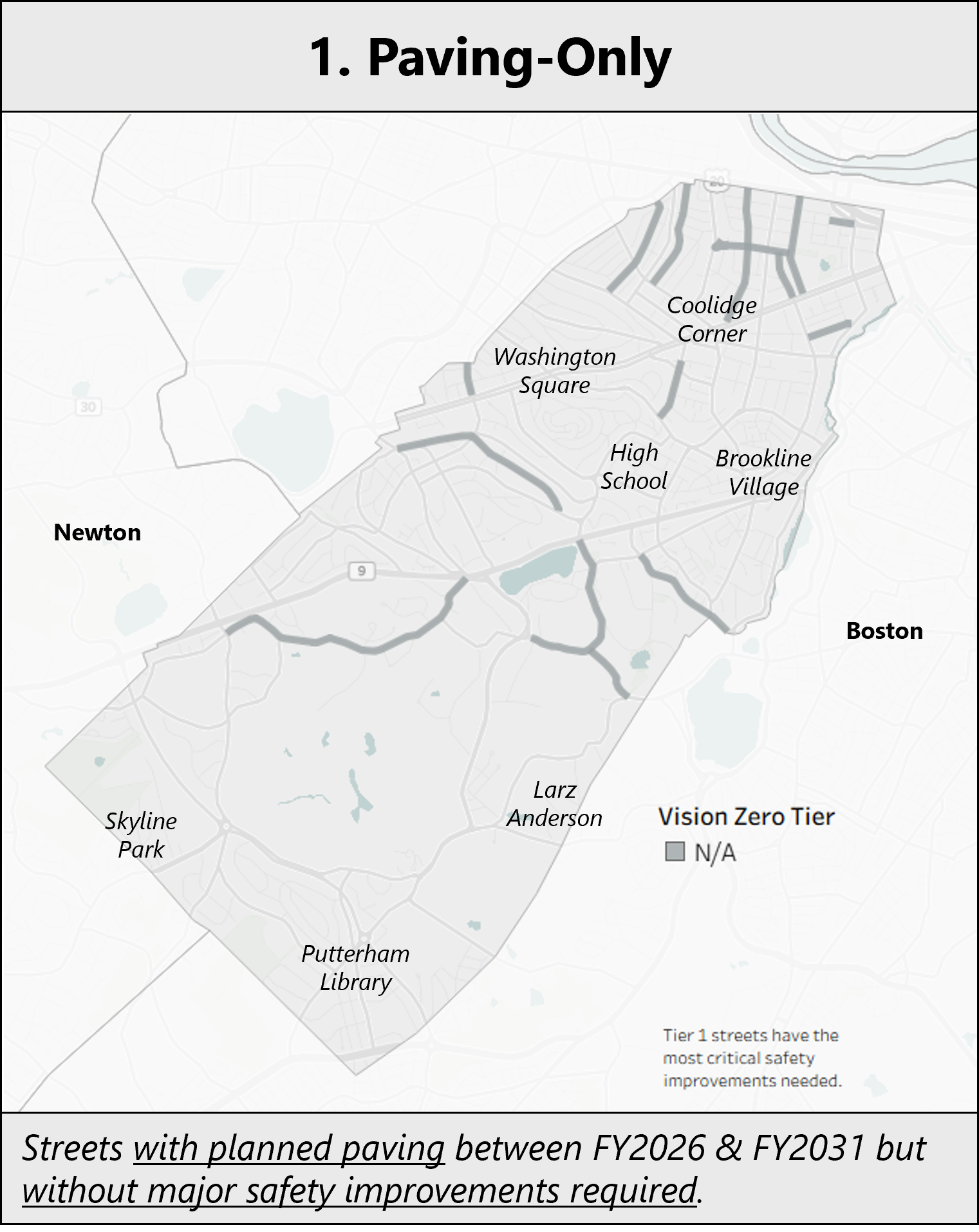
Paving-Only streets require the least amount of coordination. Streets identified under DPW’s Roadway Asset Management, Maintenance, and Preservation Policy with no safety improvement needs don’t require a prolonged public process, so each year DPW can unilaterally scope and execute this work to efficiently get these roads to a state of good repair.
The following streets are scheduled for paving but were not identified in the Vision Zero Action Plan as requiring critical safety improvements:
Planned for paving in FY2026 (ends June 30, 2026)
• Amory Street
• Colchester Street (west of Hawes Street)
• Cottage Street
• Pleasant Street
Planned for paving in FY2028
• Corey Road
• Lenox Street
• Warren Street
Planned for paving in FY2029
• Heath Street (east of Hammond Street)
Planned for paving in FY2030
• Clinton Road
• Park Street
• Powell Street
Planned for paving in FY2031
• Chestnut Street (identified as a Complete Streets priority but not Vision Zero)
• Freeman Street
• Naples Road
• Thorndike Street
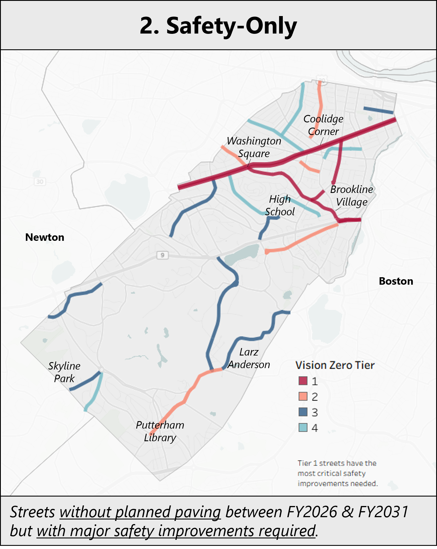
Safety-Only streets don’t have planned maintenance scheduled, so there isn’t a natural entry point (or budget) for DPW to add incremental safety improvements. As a result, some of these streets may be better-suited for longer-term planning, more thorough redesigns, and alternative funding sources. Beacon Street and Washington Street fall into this category. These “Complete Streets” redesigns are receiving significant funding from federal and state programs and feature initial design proposals with fully-separated curb-protected bicycle lanes and other significant roadway and intersection improvements
Planning and delivery of these more significant projects can take the better part of a decade or longer, but during that time the Town can implement dozens of substantive low- or no-cost safety improvements through the course of its planned repaving work across the rest of the street network.
The following streets are not scheduled for paving but were identified in the Vision Zero Action Plan as requiring critical safety improvements:
• Babcock Street
• Beacon Street (plans in progress)
• Clyde Street (south of Lee Street)
• Dean Road
• Fuller Street
• Goddard Avenue
• Grove Street
• Newton Street
• Ivy Street
• Lagrange Street
• Lee Street
• Newton Street (west of Hammond Pond Parkway)
• Saint Paul Street (south of Beacon Street)
• School Street
• Sewall Avenue
• Stanton Road
• Sumner Road
• Tappan Street (west of High School)
• Vernon Street
• Walnut Street
• Washington Street (plans in progress south of Beacon Street)
• Waverly Street
• Winchester Street
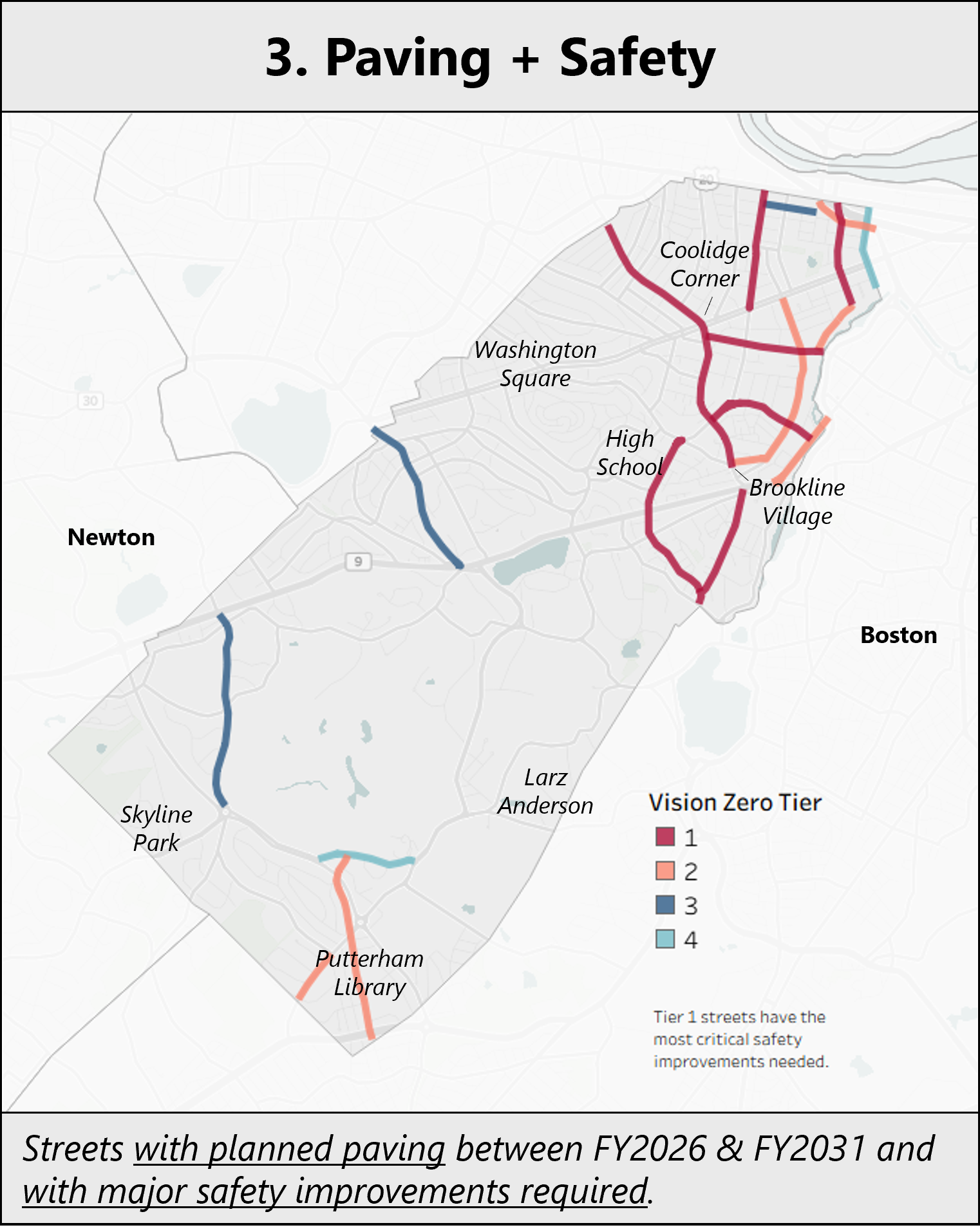
Paving + Safety streets will likely be the most challenging to manage, but they also have the potential to provide the most value to Town residents. Safety improvements for these streets will need to be made at low- or no-cost to keep the work within the limited $5-$6 million annual budget allocated to planned repaving and maintenance.
Public feedback and Transportation Board approval is needed for work done on these streets, but in order for DPW to meet its paving and maintenance objectives, the process will need to be much more rapid than the “Complete Streets” approach taken for Beacon Street and Washington Street.
To accelerate the public feedback and approval process, the Transportation Board can anticipate public needs and concerns (curbside parking expectations, commercial loading needs, MBTA bus lane-width requirements, etc.) based on prior street redesigns and propose a design that balances or addresses these concerns while still including protected bike infrastructure.
Not all Vision Zero streets need or can support protected bike lanes, but for those that do and can, a mix of parking-protected and flex-post-protected lane installations can be completed within the strict time and cost limitations that Paving + Safety streets require. These two forms of protected bike lanes don’t require expensive alterations to existing curbs or intersections. Instead, they just need paint to shift car parking away from the curb or flex-posts which cost about $15,000-$30,000 per mile to install. Parking-protected and flex-post bike lanes have the additional benefit of narrowing car traffic lanes, which lowers motorist speeds.
The following streets are scheduled for paving and were identified in the Vision Zero Action Plan as requiring critical safety improvements:
Planned for paving in FY2026 (ends June 30, 2026)
• Carlton Street
• Hammond Street
• Harvard Street
Planned for paving in FY2027
• Brookline Avenue
• Chestnut Hill Avenue
• High Street
Planned for paving in FY2028
• Cypress Street
• Longwood Avenue
• Saint Paul Street (north of Beacon Street)
Planned for paving in FY2029
• Aspinwall Avenue
• Dummer Street
• Independence Drive
• St. Mary’s Street
Planned for paving in FY2030
• Chapel Street
• Colchester Street (east of Chapel Street)
• Kent Street
Planned for paving in FY2031
• Mountfort Street
• Newton Street (west of Grove Street)
• South Street
To illustrate this approach, we can look to Aspinwall Avenue.
Paving + Safety Case Study | Aspinwall Avenue
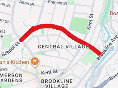
Aspinwall Avenue connects Harvard Street and Brookline Avenue.
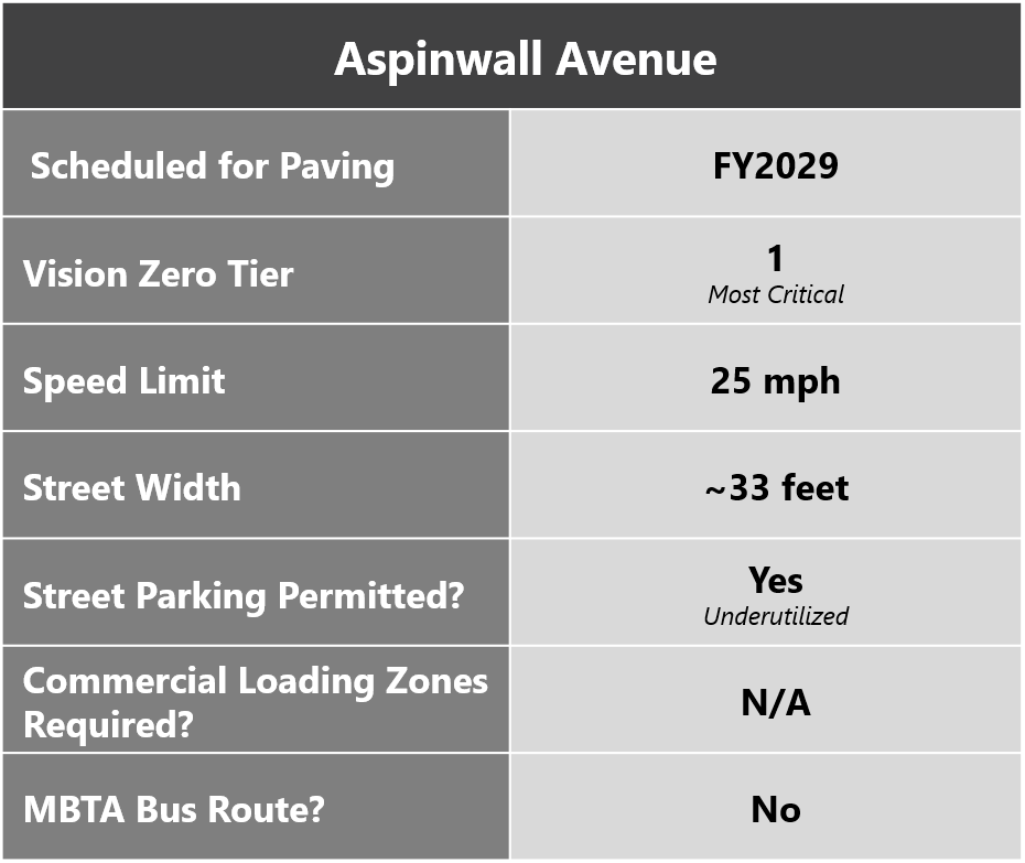
Aspinwall Avenue is a Tier 1 Vision Zero priority with paving planned for FY2029. This two-lane ½ mile residential street north of Brookline Village is approximately 33 feet wide with a 25 mph speed limit and it connects Harvard Street and Brookline Avenue. The street accommodates an average of 5,300 cars per day but it is not along an MBTA bus route.
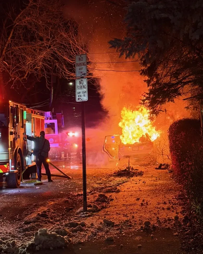
A car crash at 162 Aspinwall Avenue on Friday morning, January 23, 2026. Photo courtesy of Brookline Police Department.
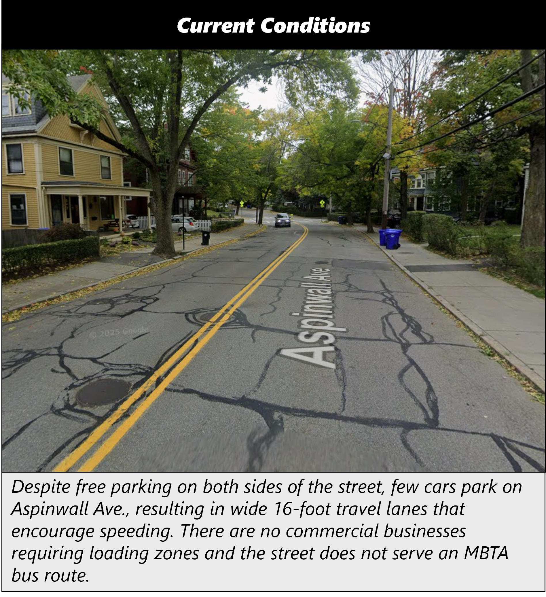
Free unmarked curb parking is available for cars on both sides of much of the street. However, few cars are usually parked along the half-mile corridor, resulting in travel lane widths of about 16 feet. Several less-traveled residential streets that intersect Aspinwall Avenue also provide free curbside parking. St. Paul’s Episcopal Church periodically draws cars to park along Aspinwall where it intersects with St. Paul Street but there are no commercial loading needs along the corridor. Cyclists and pedestrians travel along and across Aspinwall Avenue to get to the Pierce and Lawrence elementary schools, the Longwood Medical Area, Brookline Village businesses, and many other destinations.
If the Town eliminated the underutilized free curbside parking along Aspinwall Avenue, it could install two 5.5-foot bike lanes buffered by flex-posts, which would reduce vehicle travel lanes to 10.5 feet - a more-appropriate width for a 25 mph street. Bicycles would then have some protection from traveling cars and would no longer be forced to ride in the middle of the lane to get around parked cars.
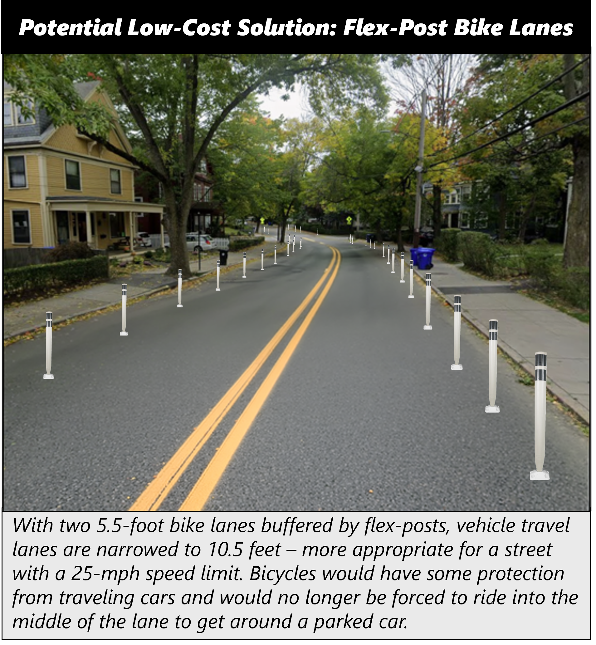
This solution is far from perfect: flex-posts are often removed during the winter months to facilitate snow plowing; the few cars that park on Aspinwall would need to park slightly farther away on other side streets; waste-removal vehicles may not currently be equipped to pick up garbage and recycling bins across a bike lane buffer; and bicyclists may still need to and/or choose to ride in the vehicle traffic lane to make left-hand turns. But this would represent a cost-effective transformation that establishes a new baseline for safe-street infrastructure on priority streets.
Measuring Performance & Informing Residents
Measuring performance is a key component of the type of transformation Brookline is seeking to realize along its street network, but the Town’s current metrics appear to be limited. They include the number of miles paved and each street’s Pavement Condition Index (PCI), which is a measure gathered every two to three years that assesses roadway quality and maintenance needs. Deaths and major injury data is available through MassDOT’s Safety Performance Dashboard.
In the context of addressing street maintenance needs, the number of miles paved and each street’s PCI are effective measures - they highlight how efficiently and cost-effectively the Town repaved streets and provide quantifiable information about street conditions over time.
However, these metrics are insufficient at assessing broader safety and accessibility performance. For instance, if major injuries remain consistent over time but bicycle use increases considerably, that indicates bicycling became safer. However, without reliable information on bicycle usage, that lesson would be lost.
A deeper dive on performance metrics is best left for another analysis, but Brookline may want to establish baseline information about miles of separated bike lanes, current bike trips, and - potentially - survey data with current perspectives from drivers, bicyclists, and pedestrians before, during, and after the substantial improvements DPW plans to make. Data collection and analysis doesn’t need to cost much money; in fact, with the Town’s plan to more-than-double its number of BlueBike stations between 2026-2030, it could use BlueBike trips as an (imperfect) proxy for overall bike ridership.
Closing Thoughts
Brookline is not alone in balancing routine street maintenance needs with plans to expand and improve its network for cyclists and pedestrians. Neighboring Cambridge and Somerville began similar transformational plans several years ago and are seeking to expand their network of protected bicycle lanes by 25-30 miles. With effective coordination and a commitment to ongoing transparency, Brookline can leverage its existing budget to improve the paved conditions of its roadways while also making them safer and more accessible for all users.